(1) The rigorous algorithms contained into the Explanatory Supplements of AE( 1961 and 1992) I got right now on my desk don’t take in account athmospheric refraction when computing a solar eclipse path, and this fact generates a little shorter curve excluding locations where totality or annularity happens with the Sun lying on the horizon line. This subject is mentioned, of course, but no analytical solution is provided. So I worked on it and found the solution. Since a long time I use as reference Espenak’s predictions published on EclipseWise, in my opinion the most accurate around, even if they don’t take into account the refraction at the edges of the path, apparently. I will take as an example the total solar eclipse occurred on CE 1724 May 22, with one path edge falling over the Italian soil.

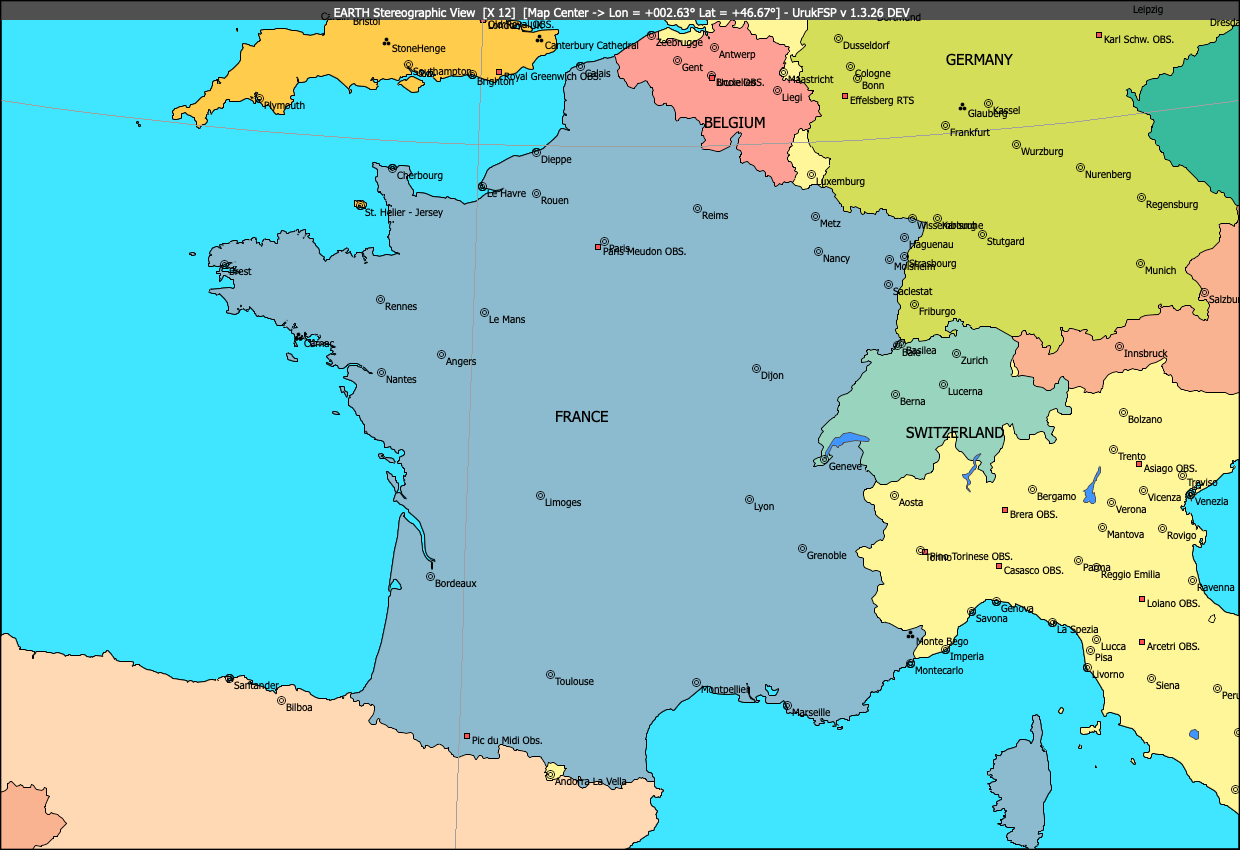
Apparently Venice is out of the path, and Trieste as well. But the effect of refraction when Sun and Moon are rising (or setting) is not negligible, so this one could be a more realistic representation of the path edge:

Ok, I colorised the map. This explains why I introduced optionally the possibility to show locations with a colored background. When you fill areas (I used the Gimp in this case) location’s name is not ruined by pixels interference. Below you can see as the maximum eclipse actually appears from Venice and Trieste.
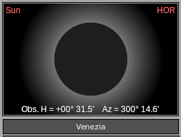
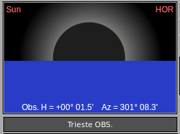
Still total there before the Sun disappears below the horizon. Looks like a good result.
(2) UrukFSP uses WGS84 spheroid for handling geodetic coordinates. This system is currently adopted by Global Positioning System (GPS). In order to follow all GPS conventions now Latitude is shown before Longitude, even in Input Fields.
(3) Geographical Coordinates : except for Location Database Editing, now the “N S E W” notation replaces the use of minus or plus sign.
(4) Location names into the Stereographic map can now be drawn with a colored background, in case the saved map needs to be colorised for a better reading (see image above).
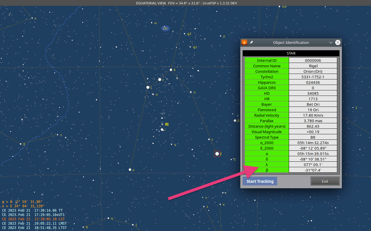
(5) Added Into G.E. data referring to a linked solar eclipse (yellow window) the Magnitude of the eclipse. This is not the Moon Radius – Solar Radius ratio, commonly showed as SDR and computed in a different way.
(6) Added new items into the EARTH view popup menu.
(7) Updated predicted DeltaT values up to 2032 published by NASA. Source is NASA CDDIS (Crustal Dynamics Data Information System) accessible via user registration. So deltaT values from 2023 to 2032 are derived by direct interpolation of these values, and no further algorithm is involved with calculation.
(8) Mean Solar Radius Value computed by Auwers (959.63″) has been replaced by the IAU(2015) recommended value 959.22″. An interesting paper about this topic here.
(9) Some cosmetic change to the forms handling Asteroids and Comets.
(10) Main menu now contains a new item, “Sites”, doing direct calls to some portals which are convenient to have on hand. So far I have added these (uh oh, something new is gonna be revealed in the background):

(11) New switch for Asteroids into the Options Form : when Zoom factor is greater than 50, Asteroids show their distance from map center. Useful when checking minimum distance during occultations.

(12) Saving a graphical Map (as a PNG or BMP file) is now done by means of a standard dialog window provided by the Operating System. This means no more filename restrictions and use of subfolders in order to keep image data more organised. The default folder is still the USR_PATH/Images but theoretically any folder can be used where the user has writing privileges, of course.
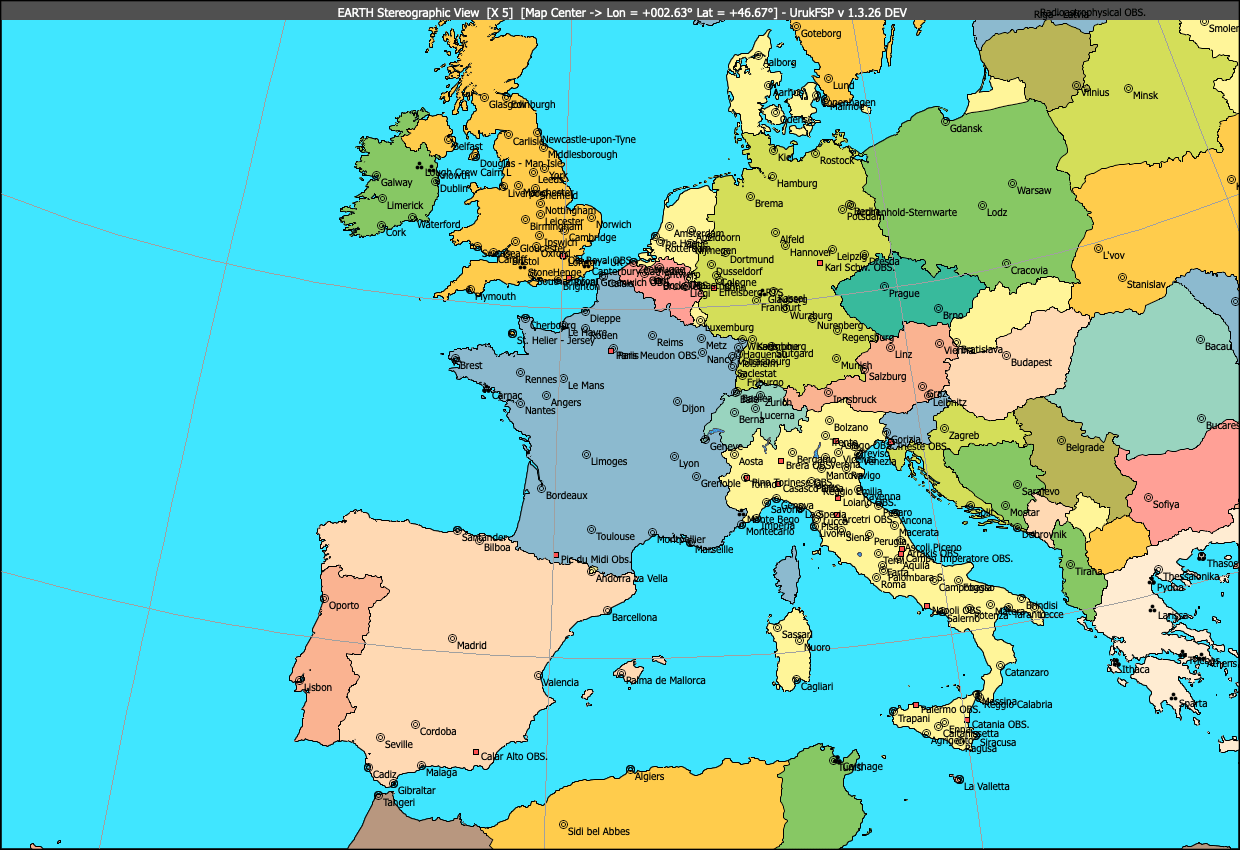
(13) Stereographic map can be switched to color via Options Form. Nation Names are stored into the standard Location Database with the new Group ID 16. The field “Altitude” in this particular case is filled with the minimum Zoom value where the nation name is shown. Almost 50 biggest lakes have been added too.
(14) During a research about Indian solar eclipses reported into the Rig Veda I noticed that sometimes ecliptical coordinates of stars are needed to be on hand (actually way more used in the antiquity than equatorial ones). So I decided to make them accessible in the equatorial view tracking info, identification request via pop-menu and in the occultable by the moon stars windows as well.

Version 1.3.1 closed. Already under test, if no relevant issue appears I guess it could be out on next weekend.

In effetti l’incidenza della rifrazione nei pressi dell’orizzonte astronomico (33-35′,variabile a seconda dei parametri di pressione atm., temperatura, ecc.) supera il diametro medio del sole, che è di 32′ circa. Nelle due immagini l’altezza indicata dell’orizzonte astronomico è riferita al centro del sole suppongo. Il fenomeno segnalato è comunque rilevante e non mi sembra che sia stato evidenziato in passato.
Certo, le altezze che indico ovunque e riferite ad un corpo celeste dotato di un diametro apparente apprezzabile sono sempre riferite al centro del disco. Le altezze corrette per il lembo superiore o inferiore mi servono in pratica solamente a scopo interno per il calcolo dei tempi del sorgere e tramonto. Sono comunque facilmente ricavabili dai dati mostrati, nel caso ad esempio volessimo ricavare l’errore strumentale di un sestante.
Per convenzione gli algoritmi rigorosi pubblicati dagli Expl.Suppl. delle AE riferiscono i propri calcoli al centro dell’ombra lunare proiettata sul piano fondamentale e senza tenere conto della rifrazione. Parlando in funzione di eventi moderni questo può avere un senso: i limiti del path di totalità al sorgere o tramonto del Sole hanno interesse nullo per le spedizioni scientifiche (non per qualche fotografo naturalista a caccia di foto ad effetto, magari) ma sono molto importanti per eclissi storiche, laddove anche le eclissi parziali avevano maggiori probabilità di essere notate in quanto il Sole poteva essere osservato tranquillamente senza esserne accecati. Inoltre in quel caso una stima del tempo locale relativo all’evento può essere fatta con una certa precisione.
Insomma, tutto questo non vuole essere una critica ad Espenak e agli altri, ma semplicemente far notare il fatto che essendo UrukFSP particolarmente attento alla ricostruzione di eclissi storiche il calcolo della rifrazione, seppure stimato su valori tipici(*) e non specifici, va preso in considerazione.
(*) l’entità della rifrazione è calcolata con valori di pressione, temperatura e umidità medi. Inoltre per convenzione i calcoli del path vengono effettuati per una località posta a 0 mt. d’altezza sullo sferoide WGS84, per cui un luogo elevato dallo stesso va comunque testato con i calcoli grafici di UrukFSP.
saluti
A.C.
Hi
Regarding the total solar eclipse of 22 May 1724, it is interesting to check the IMCCE/Paris Observatory computation for Venice.
According to IMCCE : https://ssp.imcce.fr/forms/solar-eclipses/1724-05-22/local-circumstances#map=8.17/45.205/12.047&observer=45.44476765695225/12.272279738769157
Venice is on the path of totality.
It would be interesting to find an account of the eclipse at the time by a Venetian ?
Regards
Hi,
most likely in Venice astronomers didn’t expect to witness the event. A few years before William Whiston published the map visible here (https://fineartamerica.com/featured/1-predicted-path-of-the-1724-solar-eclipse-royal-astronomical-societyscience-photo-library.html) that was thought to be the most accurate available. Eclipse path ends right before reaching Milan, 250 Km west of Venice.